...A Guide to Unique and Local NYC
This Manhattan neighborhood map shows you the heart and soul of New York City…the places New Yorkers live, eat, work, explore and the reason we all love living in New York City.
Every Manhattan neighborhood has a different vibe to it, with different shops, restaurants, cafés and attractions. These neighborhoods are almost all a 20-30 walk within (no stopping), but it might surprise you how easy it is to identify the character of each Manhattan neighborhood as you visit them – and how different things are from one block to the next.
NYC Neighborhood Maps & Guides
- Interactive Online Map
- Neighborhood Guides
- NYC Subway Map Guide
- Printable Tourist Map
- Free NYC Mini Guide
- Attractions by Neighborhood
Five NYC Boroughs
New York City has 5 boroughs, corresponding with 5 counties. When many people think of NYC, they are really thinking of Manhattan, but we have 4 other boroughs, each with it’s own unique characteristics. Our Mayor (Eric Adams) covers all 5 boroughs, which are:
- Manhattan (New York County)
- Brooklyn (Kings County)
- Queens (Queens County)
- The Bronx (Bronx County)
- Staten Island (Richmond County)
Explore the diverse neighborhoods of our NYC Boroughs with our guides to Brooklyn, Queens, the Bronx and Staten Island.
Interactive Manhattan Neighborhood Map
Roll your mouse over the Manhattan neighborhood map and click each neighborhood to learn about the best things to do and see, real estate to buy, places to eat and shops to visit during your NYC vacation.

Back to Top of Manhattan Neighborhood Map
Manhattan Neighborhood Printable Map

Back to Top of Manhattan Neighborhood Map
NYC Insider Print Map and Guide to Manhattan
NYC Insider Printable Guides
“The guides are exactly what we were looking for to help us navigate NYC and the highlights of each area.
THANK YOU for taking the time to put this together.”

“Amazing, Melissa. This is my second copy! Congratulations for this always excellent guide. I have been living in this area for 18 years, but I still leave the guide as a treat when people come to visit me by their bed. So comprehensive!”
Back to Top of Manhattan Neighborhood Map
NYC Neighborhood Guides
Download Your FREE NYC Printable Mini Guide
Manhattan Weekly brings you the latest on NYC, Events, discounts, specials, Broadway and more. New subscribers to our newsletter receive a free NYC Insider Mini Guide. If your trip is several months away, this a great way to start getting a feel for the City, when tickets are going on sale to big events, which stores are having sales, tons of my insider tips and much more.

“Your guide is a lifesaver! I purchased it almost a week ago for my upcoming trip after searching on a lark for NYC sample sales. Once I stumbled on your page, I found the resources invaluable. I have done a fair bit of planning in preparation for my ‘real’ first time trip to Manhattan (last time was a shoot in and go back out weekend) and was amazed at how organized and easy this guide was to follow. The map points along with listings are terrific, they even have cross streets for easier navigation.”
Harlem
Our Harlem neighborhood guide will show you the wonderful cultural, food, music and historic value of this landmark area, which has long, strong and proud NYC roots. The Harlem Renaissance of the 1920s began the golden age of African-American culture, literature, music, artists, theater and art, which continues to strengthen today. If you want to eat authentic soul food, hear mind-blowing jazz and gospel and clothing shop with Alicia Keys and Jay-Z, then Harlem is on your bucket list!
- Explore: Harlem Neighborhood Guide
- To Do: Apollo Theater, Striver’s Row, National Jazz Museum

Upper West Side
The Upper West Side is a residential neighborhood filled with young professionals and families. It is a great place to stay if you are looking to avoid the heavy crowds of Midtown, explore Central Park, The Museum of Natural History, the Beacon Theatre, Lincoln Center, the West Side Highway and still be about 20 minutes from most of Manhattan.
- Explore: Upper West Side Guide
- To Do: American Museum of Natural History & Planetarium, Beacon Theatre, Lincoln Center, Time Warner Center

Central Park
Central Park offers 843 gorgeous acres to explore and 100s of things to do, which is why we consider it an unofficial neighborhood. Central Park draws 38 million visits a year and is home to the Central Park Film Festival, SummerStage, Shakespeare in the Park, Ice Skating, Central Park Zoo, Bow Bridge, biking, playgrounds, the Carousel and much more.
- Explore: Central Park Guide
- To Do: Central Park Zoo, Carousel, TV and Movie Sites, Ice Skating, Loeb Boathouse

Times Square & Broadway
Times Square New York and the Theater District are some of New York City’s most popular tourist attractions. Of course, Broadway, also known as the Great White Way, is most definitely for locals as well. Spend a bit of time here and make sure to see the lights at night, the Hershey’s and M&M Stores, as well as catch a great Broadway Show.
- Explore: Times Square & Broadway NYC Guide
- To Do: Madame Tussauds Wax Museum, Broadway Shows NYC, Times Square Ball Drop New Years, M&M World & Hersheys Chocolate World

Midtown West, Koreatown, Hell’s Kitchen
Midtown West is a huge tourist area with great neighborhoods like NYC’s famous Diamond District, Hell’s Kitchen and Koreatown. Hell’s Kitchen, is the most western section and an “up-and-coming” residential area of New York City with new shops and restaurants opening often. Koreatown, just a block from the Empire State Building, is known for their restaurants and karaoke bars and clubs.
- Explore: Midtown West NYC Guide
- To Do: Empire State Building, Intrepid Sea, Air & Space Museum, Madison Square Garden, Top of the Rock, Rockefeller Center, Bryant Park, Javits Center

Garment District / Fashion Center
The Garment District, also called the Fashion District or Fashion Center, is home to many of the world’s most famous fashion designers and showrooms. The area is an amazing resource for fabrics, beads and trims, however, unless you are trade, don’t expect to walk in off the street to designer showrooms. The best way to possibly get access to private showrooms is through a private tour or a NYC Sample Sale.
- Explore: Garment District Guide
- To Do: Fashion Walk of Fame, Museum at FIT, Parsons School of Design

Chelsea & Hudson Yards
Chelsea NY is known for art galleries, nightlife and gay-friendly culture. It is a lively, vibrant neighborhood with some of New York City’s top restaurants, clubs, art and things to do outdoors and along the Hudson River. While Chelsea boundaries are West 14th-34th Streets, from 7th Ave to the Hudson River, the new Hudson Yards occupies it’s most North and West streets, West 30th to 34th Streets between 10th and 12th Avenues.
- Explore: Chelsea & Hudson Yards Guide
- To Do: The Highline, Restaurants, Clubs & Rooftops, Little Island, Upscale Shopping

Meatpacking District
The Meatpacking District, also known as the Gansevoort Market, is only a few blocks, so you cannot get lost, but it is packed with upscale restaurants, night clubs and designer shopping. Like many NY neighborhoods, the MP District retains it’s historical architecture, as it is lined with cobblestone streets and old warehouses, but, today, these same buildings house very modern shopping and dining. The heart of the Meatpacking District is Little West 12th Street.
- Explore: Meatpacking District Guide
- To Do: The Highline, Restaurants, Clubs & Rooftops, Little Island, Upscale Shopping

Greenwich Village & NoHo
Our Greenwich Village NYC Guide provides insight into one of NYC’s most cherished neighborhoods. The Village is full of history, celebrity, politics, landmarks and so much more. The NYU campus, Washington Square Park, gorgeous brownstones and cobble stone streets, amazing restaurants, tons of trees and much more make this area a local favorite.
- Explore: Greenwich Village & NoHo Guide
- To Do: Washington Square Park, NYU Campus, Astor Place, Shopping, Restaurants

West Village
The West Village is filled with tree-lined streets, beautiful old brownstones and hundreds of shops, restaurants and cafés. It is truly a quintessential NYC neighborhood, inhabited by locals and celebrities who can afford to live anywhere they choose. If you’re a Friends or Sex and the City fan, then you are already quite familiar with the West Village…now it’s time to come experience it!
- Explore: West Village Guide
- To Do: Restaurants, boutique shopping, gorgeous brownstones

SoHo
SoHo (SOuth of HOuston – pronounced How-ston) is another NYC neighborhood filled with the best shopping and restaurants. Traditionally known as a haven for artists and their lofts, it has become more upscale over the years and a much sought-after place for New Yorkers to live.
- Explore: SoHo Guide
- To Do: New York Fire Museum, Shopping, Art Galleries, Brunch & Restaurants, Broken Kilometer & Earth Room

Tribeca & The Battery
Tribeca Tribeca (TRI-angle BE-low CA-nal) NYC, is home of the namesake Film Festival, Robert De Niro’s pet project, created to promote commerce downtown after 9/11. He also owns several hotels and restaurants in the area and is spotted quite frequently. Tribeca was also the home of JFK Jr and Caroline Bessette Kennedy before their tragic death in 1999 and is filled with old warehouses, now converted into lofts, beautiful views of the Hudson River and Statue of Liberty along the West Side Highway, excellent restaurants, families, parks and NYC history.
- Explore: Tribeca & The Battery
- To Do: Hudson River Park and River Promenade, Statue of Liberty Views, Upscale & Casual Dining

Financial District and Wall Street
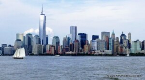
The Financial District (FiDi), at the southern tip of NYC, is one of NYC’s most bustling business and tourist areas, from Monday to Friday and is near dead on the weekends. Sights include the 9-11 Memorial & Museum, Wall Street, One World Observatory, The American Stock Exchange, the Charging Bull, the Fearless Girl and views of the Statue of Liberty.
- Explore: Financial District Guide
- To Do: One World Observatory, Staten Island Ferry, 9-11 Museum, 9-11 Memorial, Charging Bull & Fearless Girl, American Stock Exchange, The Oculus, Brooklyn Bridge, South Street Seaport and much more.

Upper East Side NYC
The Upper East Side is an upscale, residential neighborhood and home to Museum Mile, some uber-upscale shopping and Gracie Mansion. The homes on Fifth Avenue, along Central Park, are some of the most exclusive in all of Manhattan. You’ve likely seen the Upper East Side on Gossip Girl, Sex and the City, The Real Housewives of New York, I Love Lucy, Breakfast at Tiffany’s and dozens of other times on your screens.
- Explore: Upper East Side
- To Do: Metropolitan Museum of Art, Guggenheim Museum, Museum Mile, Central Park, Gracie Mansion, Upscale Shopping

Midtown East
Midtown East is a huge tourist, commercial and residential area. Around 5th Ave, the neighborhood is home to many tourist attractions, such as St. Patrick’s Cathedral, Rockefeller Center, Top of the Rock and Radio City Music Hall. Bryant Park, the New York Public Library and Grand Central Station are close together just south. Moving towards 3rd Ave and further east, the area is more residential, and generally, the restaurants are better and more affordable, with the UN being the only attraction in that part of the neighborhood.
- Explore: Midtown East Guide
- To Do: The Plaza Hotel, Upscale Shopping, Rockefeller Center, Top of the Rock, Radio City Music Hall, Bryant Park, Grand Central Station, Summit One Vanderbilt, New York Public Library, United Nations

Union Square, Flatiron, NoMad, Gramercy
Union Square (my hood!), the Flatiron District and NoMad all have a mix of residence and business tenants. Additionally, colleges such as NYU, The New School and FIT dominate the area, making it very fun and lively. It is one of the best dining and nightlife areas in Manhattan, with something for every palate and budget and offers fabulous hotels of all kinds.
- Explore: Union Square, Flatiron, NoMad, Gramercy
- To Do: Flatiron Building, Madison Square Park, Eataly, Union Square Park & Greenmarket, Harry Potter Wizarding World

East Village
While originally part of the Lower East Side, an immigrant neighborhood, the East Village, has separated itself and become home to some of the City’s best restaurants, shops and nightlife. It is full of character, diversity, fine dining, shops and live music, and includes a subsection named “Alphabet City.” East Village culture ranges from tattoo parlors and “dive bars” to some of New York City’s nicest hip and trendy hotels.
- Explore: East Village
- To Do: Blue Man Group & Stomp, St. Mark’s Place, Nightlife, Speakeasies, Curry Lane

Lower East Side NYC
Traditionally, the Lower East Side was a working class immigrant neighborhood (think “Gangs of New York”). Today it is a wonderfully ethnic and diverse neighborhood and serves as a shopping, dining and nightlife destination for many NYC locals. Even with all its modern upgrades, the LES retains a large amount of its history, especially it’s Jewish, Polish, Irish and Italian cultures. The LES also has one of the best selections of hotels in NYC – tons of boutique hotels with amenities, rooftops, skyline views and seconds from 1000s of cool restaurants and hot spots.
- Explore: Lower East Side
- To Do: Tenement Museum, Museum at Eldridge Street Synagogue, Food Tours, Nightlife, great Hotel selection

Chinatown NYC
Chinatown NYC is a small, but very densely packed area of shops and restaurants. It is really fun to walk around, enjoy the culture, pick up some souvenirs, and most definitely, eat some delicious and affordable Dim Sum, dumplings, pork buns and other amazing Chinese cuisines.
- Explore: Chinatown NYC Guide Guide
- To Do: Museum of Chinese in America (MOCA), Mahayana Buddhist Temple, Dim Sum & Dumplings

Little Italy NYC
Little Italy NYC Guide is a just a few blocks, with tons of outdoor restaurants and owners promising free wine and sangria to lure you in. Puglia is a favorite restaurant for families with their live singing and kids standing on their chairs waving napkins. Visit the new Italian American Museum, which tells the story “from Columbus to Cuomo,” the original Old St. Patrick’s Church and NYC Police Headquarters.
- Explore: Little Italy NYC Guide
- To Do: Feast of San Gennaro, Old St. Patrick’s Church, Food Tours, Italian American Museum

NYC Boroughs
Explore the diverse neighborhoods of NYC Boroughs with our comprehensive guide to Brooklyn, Queens, the Bronx and Staten Island. New York City is a melting pot of cultures and neighborhoods, each with its own unique character and charm. Whether you’re a local or a visitor, exploring the five boroughs of NYC is a must-do experience.
- Explore:NYC Boroughs Guide
- To Do: Williamsburg, Park Slope, Brooklyn Bridge, Brooklyn Museum, Barclay’s Center, Brooklyn Flea, Coney Island, Dyker Heights, Astoria, Jackson Heights, Unisphere, Citi Field, US Open, Mets, MoMA PS1, Yankees, Bronx Zoo, NY Botanical Garden, Staten Island Ferry

Share YOUR favorite travel tip, story or photo
Manhattan Neighborhood Guides
- Harlem Neighborhood Guide
- Upper West Side Guide
- Central Park
- Midtown West/ Hell’s Kitchen
- Times Square/ Broadway
- Fashion/ Garment District
- Chelsea/ Hudson Yards
- Meatpacking District
- West Village
- SoHo
- Tribeca/Battery Park City
- Upper East Side
- Midtown East
- Union Square/ Flatiron
- East Village
- Greenwich Village/ NoHo
- Lower East Side
- Chinatown
- Little Italy
- Financial District/ Wall Street
NYC Maps, Subway, Itineraries, Apps ++
- NEW!!!! Custom NYC Itineraries
- NYC Printable Map Book
- NYC Subway Map Guide
- Maps of Manhattan NYC
- Manhattan Neighborhood Maps
- New York City Street Map
- NYC Tourist Maps
- NYC Boroughs

New York City – What is Where?
|
Intrepid Sea, Air and Space Museum, Empire State Building, Madison Square Garden |
|
|
The Highline, Edge, Vessel |
|
|
Statue of Liberty, 9-11 Memorial, 9-11 Museum, One World Observatory |
|
|
Top of the Rock, FAO Schwarz, Museum of Modern Art, Rockefeller Center, The Plaza Hotel, St. Patrick’s Cathedral, Grand Central Station |
|
Back to Top of Manhattan Neighborhood Map
Manhattan Neighborhood Map Boundaries
|
Neighborhood |
Boundaries (estimated) |
Known For |
|
|---|---|---|---|
|
W 59-110, |
Museum of Natural History, Lincoln Square |
||
|
34th to 59th St, |
Business and tourist area, Diamond District |
||
|
W 39th-52nd, 7th-9th Aves |
Tourist and theater area |
||
|
W 34th to 42nd Sts |
|||
|
W14-34 |
Art galleries, nightlife, Hudson River views and activities |
||
|
Gansevoort to W15th and Hudson to the river |
Ground Zero Museum |
||
|
Houston to W14th |
Many shops and eateries, resident celebrities, |
||
|
Canal to Houston, |
Art galleries, shops, restaurants |
||
|
Park Pl- Canal, B-way- River west of West Street |
Residential, old lofts and warehouses, Lady Liberty |
||
|
below Chambers St |
Wall Street, Ground Zero, World Trade Centers |
||
|
Chambers to Delancey, |
|||
|
Canal to Broome |
|||
|
Canal to Houston |
Old and ethnic. Original NYC immigrant area. |
||
|
Houston to W14th, |
NYU, traditionally a Bohemian community with Artists and writers |
||
|
Houston to Astor |
Upscale and unique shops, restaurants, nightlife |
||
|
Houston to E14th, |
Hip, trendy, music, nightlife |
||
|
E14-17, 4th to University Pl/ |
Greenmarket, shops and dining |
||
|
42-59 and the river to 5th |
U.N., Grand Central |
||
|
E59-96; the river to 5th |
Museum Mile |
Back to Top of Manhattan Neighborhood Map